Cliffcrawl: Generating a Mountain, with example
Some excerpts from WIP rules for fantastic mountaineering campaigns.
First, from the introduction:
to the referee
If you want to run a mountain exploration adventure, first put these rules away and dream of a Mountain. Dream of vast glaciers aglimmer and soaring curtains of impassive stone; dream of queer inhabitants clung to skyborne walls and huddled in the shadowed subterrain; and most importantly, dream of wondrous, gloried snow-crowned summits, and the fantastic treasures they could hold.
With the Mountain firmly in your mind, come back and peruse these rules. They are designed to take care of things that would bog down play such as the minutiae of athletic movement or inaccessible technical knowledge, while leaving a wide space for the Mountain to come alive at the table. Take what fits and change what doesn't.
I hope you enjoy, and Climb On!
Next, rules for making a bird's eye view map of a mountain:
the Mountain
What follows is a procedure for generating a map of a mountain. It is represented both by a bird's eye view contour map, and a 'topo1' format overlaid with a grid.
altitude
First decide how tall the Mountain is. Broad strokes can be made by choosing how many zones of altitude the Mountain passes through.
- Foothills (0-1000m). Diverse fauna and flora, frequent signs of civilisation.
- Montane (1000-2000m). Wilder, steeper, and more rugged terrain.
- Subalpine (2000-2500m). Start of the mid-level cloud layer. Higher winds, lower temperature, thinning vegetation.
- Alpine (2500-3000m). The 'tree line'. Flora is restricted to shrubs, mountain flowers, moss, lichen.
- Snow (3000-6000m). Frozen year-round.
- Death zone (6000+) The roof of the world. Oxygen supplementation routinely required.
Random method: roll two die. The lower die is the starting elevation. The higher die is the elevation of the summit.
contour map
Produce a bird's eye map. Start from the summit. With a pen, draw a misshapen blob the size of your thumbnail in the center of the page. The more misshapen and angular, the more chaotic and less cone-shaped the Mountain will be.
With pencil, draw a series of snug-fitting contours expanding out from the summit, at intervals of 1 or 0.5 cm. Contours that are close together create steep terrain, while those father apart make it flat.
Every ten or fifteen contours, do a contour in pen. This represents the border of an altitudinal zone.
If the contours lack variation or drama, roll a die and add that many secondary summits to this contour layer. These anomalies will yield new and exciting developments as the contours ripple outwards.
With the contours complete, determine major features. The location of major cliff walls and plateaus will be obvious from the spacing of contours.
For special features, use a 'die drop' method: take up to six die and drop them onto the map. At the position of each die, inscribe a label corresponding to the face-up number of the die.
- Water feature
- Manmade (ruin, settlement)
- Snow/Rubble Field
- Cave
- Bad ground (volcanic, swamp, glacier)
- Wonder (treasure, revelation, vista)
Spend as much time as you want labelling various features. The more detail, the better. Paths and trails will follow the flattest sections of terrain, while water tends to follow the downward path of least resistance, often concentrating down steep gulleys.
And my example:
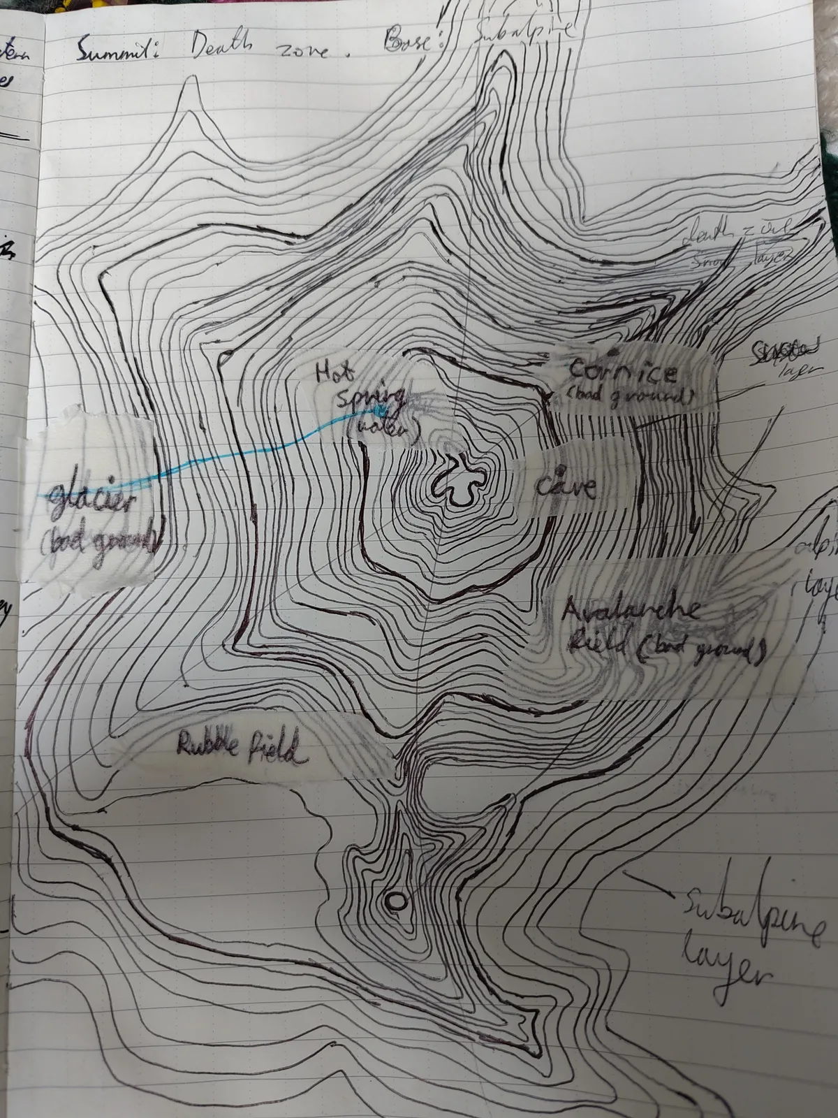
Here we have a mountain that begins at subalpine height and summits in the death zone.
Features include a steep snowy eastern face prone to cornices and avalanches, with a cave near the summit. On the western face, a geothermic hot spring trickles down steep, bald rock to a glacier far below. South, a flat patch in the shadow of a secondary summit is littered with huge shards of rubble.
I enjoyed this procedure. It took about forty minutes to get to this point, and it had the same pleasing feeling of surprising me as it took shape that dungeon stocking does.
On an additional note, I found the masking tape very useful for making labels, and as a bonus, can remove these labels later to create a blank player handout photocopy. A technique I will probably be doing more of.
Well that's it for today. Until next time,
Climb On!
climbing jargon for a hand drawn representation of a rock face, illustrating the various routes on it↩